Publication
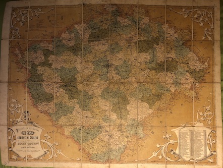
Politicka a mistopisna mapa Kralovstvi ceskeho
Erben Josef
Politicka a mistopisna mapa Kralovstvi ceského obsahujici veskery obce nad 300 obyvatel, vsecky fary, filialni kostely a klastery, sidla byv. panstvi, vsecky silnice a zeleznice, posty a stanice telegrafni, (vsecko podle nejnovejsiho stavu), znamenitejsi zamky a ssutiny atd. atd. Sestavil prof. Josef Erben. Vyvedeni a tisk litograf. ustavu Bedricha Sandtnera v Praze, Vacl. nam. Nice folding lithographic map taped on canvas, the map was published in 1850 - 1860 and its scale is 1 : 418 000. The map is dirty with distinct signs of usage and with brownish spots, there is a small library stamp in the lower left corner. 73 x 94 cm, one map sheet divided into 32 parts.
Download more photographs »»
Download more photographs »»
Illustrator:
Publisher:
K. Jansky, Jindrichuv Hradec a Tabor
Year: 1850
Number of copies: ?
Edition: ?
Cover:
original half cloth
Condition:
damaged
Price: 3700 CZK

